Guarlford History Group
The Pack Horse Way and the Old ElmThere are still traces of a packhorse way between the post box at Hall Green and Chance Lane. Marjorie recounts that two members of the South Worcestershire Archaeology Group recorded a section of this packway during the summers of 1988 & 1989. Its position relative to the modern road alongside which it runs was noted, as well as the nature of the packway itself and its immediate surroundings. The Ordnance Survey Grid reference for the most easterly part recorded (at Chance Lane) is S080554535. The packway is drawn on a Foley estate map made in 1744 by John Doherty, and is shown to extend from present day Barnards Green (the east side of Great Malvern) to Guarlford village, a distance of approximately 2 km. At the present time only the centre section, length approximately 140 metres, is still visible. It runs to the north of the main road along a broad roadside verge owned by the Malvern Conservators and is adjacent to houses and gardens, and a hedge bordering a field. The ditch along the hedge is sometimes broadened and deepened into a pond area, perhaps where clay was dug out for wattle and daub for buildings. The packway passes through the original village of Baldenhall, first recorded in the 10th century but largely deserted by the mid 16th century when the settlement had moved uphill nearer Malvern Priory. The packway passes close by the earthworks of the village, to the East and West of the junction with Hall Green near the Fladder pool, still visible on common land owned by the Malvern Conservators. Two deserted cottage sites of later date are adjacent, and ditches alongside the packway are interrupted to allow access to them. The large field behind the cottage sites still has areas of ridge and furrow and may represent some of the medieval arable areas of Baldenhall. (note: sadly the ridge and furrow disappeared when the field was ploughed in 2013.)
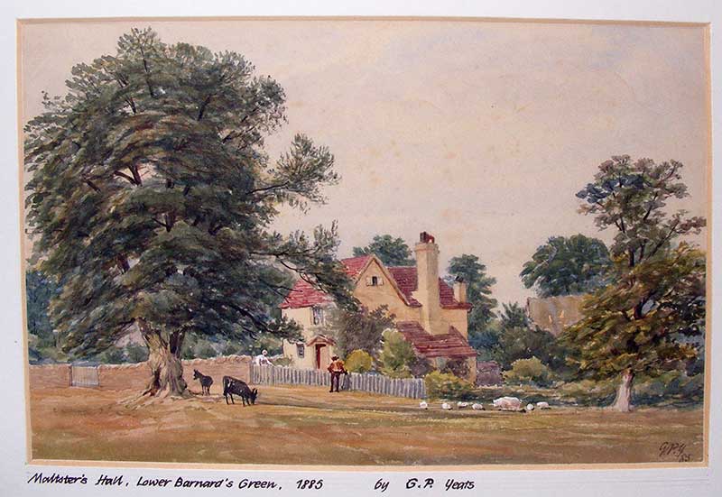
Maltster's Hall, Lower Barnard's Green, 1885, by GP Yeats source: Malvern Libray The painting above by George Paterson Yeats dated 1885 shows the two cottages, since demolished, and the tithe barn behind. Behind the tree on the left can just be glimpsed the red brick barn which has recently been converted into the dwelling now known as Rose Cottage, which has a tarmac drive to the main road. Possibly Maltster's Hall was the name at the time; hops used to be grown in adjoining fields, but lattery the cottages were known as Jessamine and Lashford cottages which were of black and white timber frame construction, otherwise closely matching the painting. At one point a broad track crosses the Packway to the site of a small tithe barn in a field (at Rose Farm), marked on the 1744 map. The packway was grass-covered until the 1980's when use by an increasing number of walkers revealed part of the original surface. This consists of Malvern stones of variable size but mostly quite small. The width appears to have been about 150cm ( about 5 feet) with a ditch each side. Some wear has taken place at the edges and ditches are not always present on both sides. At one point the packway crossed a hollow, and a short causeway was built to enable the bridging of a narrow gully. Stone abutments for the bridge are partly exposed. The Old ElmAt the head of Hall Green, adjacent to the settlement earthworks is the site of Old Elm, also called Middle Elm and Friar's Elm, which stood near the horse trough.
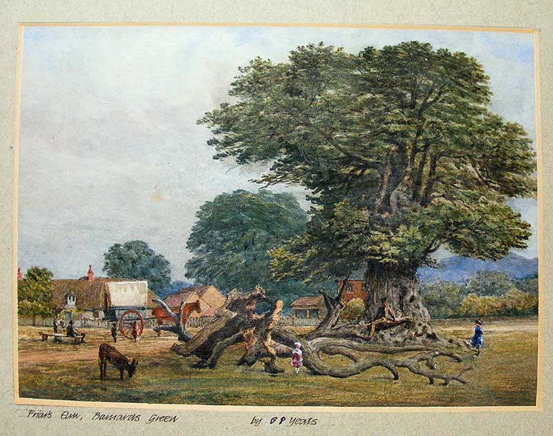
Friar's Elm, Barnards Green, circa 1890, by GP Yeats source: Malvern Library This tree is recorded on the 1744 map. Between 1856 and 1877 it was described by Edwin Lees the Victorian Naturalist who co-founded The Worcestershire Naturalists Club in 1847 as 'remnant of a giant tree'. It was surrounded by iron railings until they were taken away to make armaments in World War Two. The tree measured more than 24 feet round the trunk at a height of 3 feet from the base. This suggests a planting date in the early 16th century. It lasted until the 1950's by which time it had died. The mound representing the base of the trunk is still visible immediately alongside the packway which appears to skirt round the tree, although it may have been partly destroyed by the tree's increasing girth. Alf Young recalled the Old Elm in the days before the Second World War:
Rev Arthur Pritchard, who is said to have put the notice on the tree, died in 1933 and is buried in Guarlford churchyard. He had been vicar of Rowington in Warwickshire for 27 years. The eastern section of the Packway has not been located; near Guarlford it appears to have been covered by the modern road, constructed about 1832. At the western end the road can be traced by probing and noting traces of ditches, for a short distance, after which it disappears under the main road. Based on South Worcestershire Archaeology and Local History Newsletter no 47 1993 |